
Претраживање
Приказ резултата 31-40 од 266
Evaluation of normal heights by the means of global navigation satellite systems and global geopotential model
(Glasnik Srpskog geografskog drustva, 2015)
This paper presents geometrically and physically defined height systems, along with their evaluation by the means of Global Navigation Satellite Systems (GNSS) and Global Geopotential Models (GGM). The paper defines ellipsoid ...
Estimating double side-channel spillway capacity / Procena propusne moći dvostrukog bočnog preliva
(Udruženje za tehnologiju vode i sanitarno inžinjerstvo, Beograd, 2009)
The capacity of the double side-channel spillway, consisting of the two spillways, with channels joining into a common single branch, is estimated in this paper. For the specific site conditions, such an arrangement may ...
Estimation of flow accumulation uncertainty by Monte Carlo stochastic simulations / Ocena nesigurnosti prostorne koncentracije oticaja primenom Monte Karlo stohastičkih simulacija
(Univerzitet u Beogradu - Šumarski fakultet, Beograd, 2013)
Very often, outputs provided by GIS functions and analysis are assumed as exact results. However, they are influenced by certain uncertainty which may affect the decisions based on those results. It is very complex and ...
Long-term changes of annual and seasonal flows: A case of the Sava River / Dugoročne promene godišnjih i sezonskih proticaja - primer reke Save
(Jugoslovensko društvo za odvodnjavanje i navodnjavanje, Beograd, 2014)
This paper investigates the long-term changes in the hydrological time series. For this purpose, we use the trend analysis. The trend analysis is performed by using the standard Mann-Kendall trend test and by using the ...
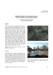
Calculation of stone sill overflowing during low discharges / Proračun prelivanja kamenog praga u rečnom koritu pri malim vodama
(Jugoslovensko društvo za odvodnjavanje i navodnjavanje, Beograd, 2010)
This paper is inspired by a stone sill designed in the channel of the Velika Morava river (near Markovački bridge, Serbia), in order to ensure water supply of the Thermal Power Plant 'Morava' during low flows, and to ...
Geometry of twisted surfaces applied on horizontal communications in architecture / Geometrija spiralnih površi primenjena na horizontalne komunikacije u arhitekturi
(Udruženje inženjera građevinarstva, geotehnike, arhitekture i urbanista "Izgradnja", Beograd, 2013)
Contemporary technologies and materials continuously challenge structural designers, as well as architects, to achieve unique applications of various geometric surfaces. Twisted structures are actual and numerous in building ...
Problems in creating flood hazard maps / Problemi pri izradi karata ugroženosti od poplava
(Jugoslovensko društvo za odvodnjavanje i navodnjavanje, Beograd, 2014)
This paper deals with problems of creating flood hazard maps, considering methodology and problems of its implementation in practice. A case study, pertaining to production of flood hazard maps for municipality Čačak in ...
The measurement of inclination on gravity concrete dams using the tiltmeter instrument / Merenje nagiba kod gravitacionih betonskih brana primenom instrumenta tiltmetar
(Savez inženjera i tehničara Srbije, Beograd, 2015)
The measurement of inclination on gravity concrete dams using the instrument tiltmeter is described and discussed with special reference on obtained results on the dam 'Đerdap 2' acquired in the three years period. Tiltmetar ...

Design of circular composite CFT columns according to Eurocode 4 / Analiza nosivosti kružnih CFT stubova prema Evrokodu 4
(Udruženje inženjera građevinarstva, geotehnike, arhitekture i urbanista "Izgradnja", Beograd, 2013)
This paper presents a simplified method for calculation of bearing capacity of composite columns according to the European standard for the calculation of composite steel and concrete structures - Eurocode 4. Resistance ...
Flood risk mapping / Kartiranje rizika od poplava
(Jugoslovensko društvo za odvodnjavanje i navodnjavanje, Beograd, 2009)
The paper considers the methodology for the mapping flood zones, flood damages and flood risk. The emphasis is on the development of synthetic flood damage functions, used for the determination of the expected annual ...