
Претраживање
Приказ резултата 111-120 од 120
Experiment design of the terrestrial laser scanning of elongated objects
(Savez geodeta Srbije, Beograd, 2014)
In high-demanding engineering applications, the latest performance improvements of the terrestrial lasers scanning (TLS) system and price decreasing trend shows the significant potential of this technology. Beside the fact ...
Mortgage market in the republic of Serbia: present situation and prospects
(Geodetski vestnik, 2013)
This paper discusses the development of mortgage loans market in the Republic of Serbia through development of the instruments for provision of legal security of investments - both to creditors and to debtors. It explains ...
Sprovođenje urbane komasacije u slučaju postojanja neadekvatnih planskih rešenja
(Zbornik radova, VI hrvatski kongres o katastru, 2018)
Parameter estimation and accuracy analysis of the free geodetic network adjustment using singular value decomposition
(Faculty of Mechanical Engineering in Slavonski Brod, Faculty of Electrical Engineering in Osijek, Faculty of Civil Engineering in Osijek, 2014)
In order to determine the vector of the coordinates of the free geodetic networks by the least square adjustment, it is necessary to solve a singular system of linear equations and to find the inverse of a singular matrix. ...
Planning for sustainable development of local municipality / Planiranje održivog razvoja jedinice lokalne samouprave u Republici Srbiji
(Savez inženjera i tehničara Srbije, Beograd, 2012)
The problem of Sustainable Municipality development in Republic of Serbia is quite specific. All official agree that the development is quite slow or stopped. Forming the new association of communities and towns the process ...
Positional accuracy of geographical information and recent standards for its evaluation / Položajna tačnost geografskih informacija i savremeni standardi za njeno ocenjivanje
(Srpsko geografsko društvo, Beograd, 2011)
Positional accuracy is important quantity element of quality of geographical information in digital as well as in analoguos form. This paper points to importance and necessity of evaluation of positional accuracy in recent ...
Evaluation of positional accuracy of digital topographic maps at scale 1:25 000 (DTM25) on the basis of STANAG 2215 standard / Ocenka pozicionnoj točnosti na cifrovoj topografičeskoj karte masštaba 1:25 000 (TK25), razrabotannoj v sootvetstvii so standartom «STANAG 2215»
(Univerzitet odbrane u Beogradu - Institut za naučne informacije, Beograd, 2018)
The paper describes the results of the positional accuracy assessment of digital topographic maps at scale 1: 25 000 produced by the Serbian Military Geographic Institute (MGI). The test for the horizontal and vertical ...
Mathematical models of rhumb line and their application / Matematički modeli loksodrome i njihova primena
(Savez inženjera i tehničara Srbije, Beograd, 2011)
The paper analyses some models of rhumb line on the ellipsoid, sphere and map projection. In geodesy and cartography, rhumb line is a complex curve on the earth's surface that crosses every meridian at the same oblique ...
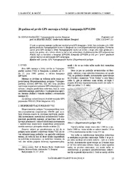
Twenty years from the first GPS measurements in Serbia: Campaign EPVGI90 / 20 godina od prvih GPS merenja u Srbiji - kampanja EPVGI90
(Savez inženjera i tehničara Srbije, Beograd, 2010)
This paper describes measurements and shows the results of the first GPS campaign taken in Serbia, realized by Military Geographical Institute from Belgrade in July 1990, within its Experimental geodetic network. As a ...
Landslide susceptibility assessment using SVM machine learning algorithm
(Engineering Geology, 2011)
This paper introduces the current machine learning approach to solving spatial modeling problems in the domain of landslide susceptibility assessment. The latter is introduced as a classification problem, having multiple ...