
Search
Now showing items 21-30 of 214
Terrain correction computations using digital density model of topographic masses
(Zvava Geodetov Slovenije, 2018)
This paper presents the determination of terrain correction by the means of the Digital Density Model (DDM) of topographic masses (Earth's crust mass above the geoid) for the territory of Serbia. The DDM is determined using ...
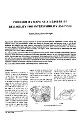
Probability maps as a measure of reliability for indivisibility analysis
(Institut za arhitekturu i urbanizam Srbije, Beograd, 2005)
Digital terrain models (DTMs) represent segments of spatial data bases related to presentation of terrain features and landforms. Square grid elevation models (DEMs) have emerged as the most widely used structure during ...
Metoda laserskog skeniranja u geodetskom inženjerstvu
(Građevinski kalendar, 2017)
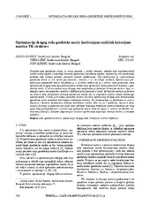
Second order design of geodetic network using different TK structured criterion matrices / Optimizacija drugog reda geodetske mreže korišćenjem različitih kriterijum matrica TK strukture
(Savez inženjera i tehničara Srbije, Beograd, 2012)
Geodetic network design for numerous practical applications (surveying, staking out of characteristic points of an object in construction, control of geometry of a built-up object, monitoring, etc) represents a problem ...
The method of the calculation of the terrain slope in the raster GIS and DTM application / Određivanje nagiba terena u rasterskim GIS i DMT aplikacijama
(Republički geodetski zavod Srbije, Beograd, 2003)
Various methods for the calculation of the terrain slope used in the gridded DTMs are presented in this work. Some of the results obtained from research based on the efficiency of the application of these methods are also ...
Prototype of the 3D Cadastral System Based on a NoSQL Database and a JavaScript Visualization Application
(2019)
3D cadastral systems are more complex than traditional cadastral systems and they require more complex technical solutions and innovative use of developing technologies. Regarding data integrity and data consistency, 3D ...

Current activities regarding matching the national reference frame to ETRS of Republic of Serbia and the surrounding countries / Dosadašnje aktivnosti uklapanja postojećih državnih koordinatnih sistema u ETRS Republike Srbije i zemalja u okruženju
(Republički geodetski zavod Srbije, Beograd, 2009)
In the world, as well as us, all the greater use of GPS technology, there is a justified need for the determination of transformation models between existing and new reference system. The paper presents a GPS reference ...
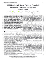
GNSS and SAR Signal Delay in Perturbed Ionospheric D-Region During Solar X-Ray Flares
(IEEE (Institute of Electrical and Electronics Engineers), 2019)
We investigate the influence of the perturbed (by a solar X-ray flare) ionospheric D-region on the GNSS and SAR signals. We calculate a signal delay in the D-region based on the low ionospheric monitoring by very low ...
Application of Google Maps API service for creating web map of information retrieved from CORINE land cover databases / Primena Google Maps API servisa za izradu web karte informacija izvedenih iz CORINE baza podataka o zemljišnom pokrivaču
(Srpsko geografsko društvo, Beograd, 2010)
Today, Google Maps API application based on Ajax technology as standard web service; facilitate users with publication interactive web maps, thus opening new possibilities in relation to the classical analogue maps. CORINE ...
Dasymetric modelling of population dynamics in urban areas
(Geodetski vestnik, 2013)
Solving the problem of publicly available census data disaggregation has preoccupied numerous researchers intensively A noteworthy advance in the methodology was made thanks to the contemporary storage and presentation of ...