
Претраживање
Приказ резултата 11-14 од 14
Field procedure for estimation of antenna phase center variation with expanded measurement uncertainty calculation
(University of Montenegro, Faculty of Civil Engineering, 2022)
Antenna phase center of GNSS receiver is the point where the signals transmitted from satellites are collected. However, this point is not necessarily the physical center of antenna (geometric center of antenna). In general, ...
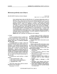
The Danube reference geodetic network / Referentna geodetska osnova Dunava
(Savez inženjera i tehničara Srbije, Beograd, 2007)
The Danube is most important river in Europe today. It relates The Western European countries with The Eastern. The safety of the flyway is a primary aim of the Serbian company PLOVPUT which is in charge to make it to be ...
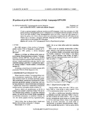
Twenty years from the first GPS measurements in Serbia: Campaign EPVGI90 / 20 godina od prvih GPS merenja u Srbiji - kampanja EPVGI90
(Savez inženjera i tehničara Srbije, Beograd, 2010)
This paper describes measurements and shows the results of the first GPS campaign taken in Serbia, realized by Military Geographical Institute from Belgrade in July 1990, within its Experimental geodetic network. As a ...
The global positioning system in geodetic surveying / Tehnologije globalnog sistema za pozicioniranje u funkciji geodetskog premera
(Savez inženjera i tehničara Srbije, Beograd, 2005)
The main task of the surveying is definition, identification, demarcation, measuring and mapping of the boundaries of the natural and artificial objects on the Earth surface. To define the relationship between points, the ...