
Претраживање
Приказ резултата 41-50 од 405
Evaluation of positional accuracy of digital topographic maps at scale 1:25 000 (DTM25) on the basis of STANAG 2215 standard / Ocenka pozicionnoj točnosti na cifrovoj topografičeskoj karte masštaba 1:25 000 (TK25), razrabotannoj v sootvetstvii so standartom «STANAG 2215»
(Univerzitet odbrane u Beogradu - Institut za naučne informacije, Beograd, 2018)
The paper describes the results of the positional accuracy assessment of digital topographic maps at scale 1: 25 000 produced by the Serbian Military Geographic Institute (MGI). The test for the horizontal and vertical ...

The analysis of horizontal positional accuracy of the Digital topographic map 1:50 000 produced by Military Geographical Institute / Analiza horizontalne položajne tačnosti Digitalne topografske karte 1:50 000 izdanja Vojnogeografskog instituta
(Savez inženjera i tehničara Srbije, Beograd, 2009)
This paper describes methodology used for assessment the horizontal positional accuracy of Digital topographic map in scale 1: 50 000 produced by Military Geographical Institute, and gives review of obtained results. Two ...
The Danube reference geodetic network / Referentna geodetska osnova Dunava
(Savez inženjera i tehničara Srbije, Beograd, 2007)
The Danube is most important river in Europe today. It relates The Western European countries with The Eastern. The safety of the flyway is a primary aim of the Serbian company PLOVPUT which is in charge to make it to be ...
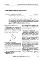
Mathematical models of rhumb line and their application / Matematički modeli loksodrome i njihova primena
(Savez inženjera i tehničara Srbije, Beograd, 2011)
The paper analyses some models of rhumb line on the ellipsoid, sphere and map projection. In geodesy and cartography, rhumb line is a complex curve on the earth's surface that crosses every meridian at the same oblique ...
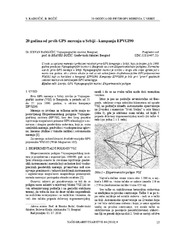
Twenty years from the first GPS measurements in Serbia: Campaign EPVGI90 / 20 godina od prvih GPS merenja u Srbiji - kampanja EPVGI90
(Savez inženjera i tehničara Srbije, Beograd, 2010)
This paper describes measurements and shows the results of the first GPS campaign taken in Serbia, realized by Military Geographical Institute from Belgrade in July 1990, within its Experimental geodetic network. As a ...
The global positioning system in geodetic surveying / Tehnologije globalnog sistema za pozicioniranje u funkciji geodetskog premera
(Savez inženjera i tehničara Srbije, Beograd, 2005)
The main task of the surveying is definition, identification, demarcation, measuring and mapping of the boundaries of the natural and artificial objects on the Earth surface. To define the relationship between points, the ...
Geodetic method using in obtaining designed geometry of civil structures / Primena geodetskih metoda u ostvarivanju kvalitetne geometrije građevinskih objekata
(Savez građevinskih inženjera Srbije, Beograd, 2009)
In this article short methodology of control measurements on engineering structures is explained. Special attention is given to the procedure of decision making related to the significance of points movement.
Parameter estimation and accuracy analysis of the free geodetic network adjustment using singular value decomposition
(Faculty of Mechanical Engineering in Slavonski Brod, Faculty of Electrical Engineering in Osijek, Faculty of Civil Engineering in Osijek, 2014)
In order to determine the vector of the coordinates of the free geodetic networks by the least square adjustment, it is necessary to solve a singular system of linear equations and to find the inverse of a singular matrix. ...
A presentation method of students’ assignment in geometry-intersection of two surfaces of second order
(Serbian Society for Geometry and Graphics (SUGIG)Faculty of Civil Engineering, University of BelgradeAkademska misao, Beograd, 2016)
There are two courses concerning geometric topics in the freshman studies at the Faculty of Civil Engineering in Belgrade: Descriptive Geometry for civil engineers and Computational Geometry, for geodetic engineers. In the ...
Permanent professional education of surveyors in Serbia / Permanentna profesionalna edukacija geodeta u Srbiji
(Republički geodetski zavod Srbije, Beograd, 2006)
The last decade starting from 2000 was marked by essential changes in Serbia and it is reasonable to call it as a period of transition. Though the content of surveying curricula vary between countries, some trends can be ...