Search
Now showing items 391-400 of 405
A digital solution for unlocking the urban mining potential of the residential building stock through the integration of BIM and GIS
(Conference on interdisciplinary and transdisciplinary research for sustainable development, 2022)
The construction industry consumes up to half of the excavated primary resources and
generates one-third of total waste annually, impacting the environment and society. To
reduce this impact, maintaining the primary ...
One algorithm for testing annulling of mixed trigonometric polynomial functions on boundary points
(TELFOR, ETF, Bulevar kralja Aleksandra 73, 2022)
This paper considers one problem of modern automated
theorem provers. While there are many different numerical
methods for computation of real roots of polynomials, theorem
provers require higher level of assurances of ...
Airborne Laser Scanning to Digital Elevation Model – LAStools approach
(IPSI, Dalmatinska 55, 11000 Belgrade, Serbia, 2023)
Airborne Laser Scanning (ALS) is one of the most popular and cost-effective approaches for collecting Digital Elevation Model (DEM) data. This especially applies to large areas, forested areas, areas with dense vegetation ...
Rockfall simulation on a rock slope along E75 road at km 890+725 to 891+093
(Willey Ernst and Sons, 2018)
The section of E75 motorway under construction was subjected to simulation of potential rockfall hazard. 3D point-cloud surface model of the rock slope, obtained by a combination of LiDAR and UAV techniques, was used for ...
Long-term rockslope monitoring and rockfall prediction
(International Association for Engineering Geology and the Environment, 2021)

Pre-failure deformation monitoring as rockfall prediction tool
(IOP Publishing, 2021)
In this article, we are elaborating an example of predictive rockfall assessment by
using Terrestrial Laser Scanning (TLS) in monitoring a road cut, hosted in flysch rock formation,
near Ljig in Serbia. A sequence of ...
Implementation of Land Readjustment in Serbia – Based on Experiences in the City of Bor
(Faculty of Civil Engineering and Architecture, University of Nis, 2022)
The paper presents the process of implementing land readjustmentin the Republic of Serbia from the initial thinking, through the intensification of research and pilot projects to the first projects that are implemented in ...
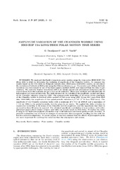
Measuring Chandler Wobble amplitude variations using IERS EOP C04 data
(Astronomska opservatorija i Matematički fakultet - Odeljenje za astronomiju, 2023)
We analyzed the Earth's long-term polar motion using the time series IERS EOP C04 (from 1984 to 2023) to determine the variation of amplitude of the Chandler wobble. To compare the results based on the C04 with the Belgrade ...
Determinations of the preliminary coordinates for the new GNSS permanent station network in Serbia
(SGEM, 51 Alexander Malinov blvd, Sofia, 1712, Bulgaria, 2022)
The new network of permanent GNSS (Global Navigation Satellite System) stations should be established by the end of this year. At the moment, 18 permanent stations are already established. All stations coordinates must be ...