Приказ основних података о документу
Laser altimetry surveying
Lasersko altimetrijsko snimanje
| dc.creator | Nestorov, Ivan | |
| dc.creator | Beljin, Jugoslav | |
| dc.creator | Martinović, Nebojša | |
| dc.date.accessioned | 2019-04-19T14:10:57Z | |
| dc.date.available | 2019-04-19T14:10:57Z | |
| dc.date.issued | 2006 | |
| dc.identifier.issn | 1451-0561 | |
| dc.identifier.uri | https://grafar.grf.bg.ac.rs/handle/123456789/118 | |
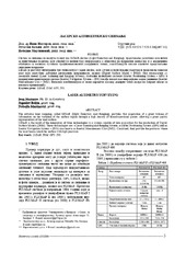
| dc.description.abstract | The airborne laser mapping, called LIDAR (LIght Detection And Ranging), provides fast acquisition of a great volume of information on the variation of the surface region through a high density of three-dimensional points, allowing a great quality representation of the land surface. LIDAR is the result of the integration of three technologies in a system capable of data acquisition for the production of Digital Surface Models (DSM). These technologies are: a Laser Scanning and Ranging System, a Global Positioning System (GPS) and an Inertial Navigation System - (INS) also known as Inertial Measurement Unit (IMU). Combined, they provide the positions where the laser beams touch the surface with high precision. | en |
| dc.description.abstract | Sistem za snimanje iz vazduha poznat kao LiDAR sistem (Light Detection and Ranging), predstavalja relativno nov način za prikupljanje podataka koji obezbeđuje veliki broj informacija o objektima na površini zemlje kao i o zemljišnim oblicima sa velikom gustinom trodimenzionalnih koordinata tačaka, omogućavajući visoki kvalitet predstavljanja snimljene površine. LiDAR je rezultat integracije tri tehnologije u jedan sistem, koji služi za prikupljanje podataka i predstavlja idealan alat koji omogućava dobijanje digitalnih površinskih modela (Digital Surface Model - DSM). Ove tehnologije su laserski skener (Laser Scanning and Ranging System), globalni pozicioni sistemi (Global Positioning System - GPS) i inercijalni navigacioni sistem (Inertial Navigation System - INS) takođe poznat kao inercijalna merna jedinica (Inertial Measurement Unit - IMU). Njihovom kombinacijom se može odrediti položaj dodirne tačke lasera na površi zemlje sa visokom preciznošću. | sr |
| dc.publisher | Republički geodetski zavod Srbije, Beograd | |
| dc.rights | openAccess | |
| dc.source | Geodetska služba | |
| dc.subject | LiDAR | en |
| dc.subject | DSM | en |
| dc.subject | GPS | en |
| dc.subject | INS | en |
| dc.subject | LiDAR | sr |
| dc.subject | DSM | sr |
| dc.subject | GPS | sr |
| dc.subject | INS | sr |
| dc.title | Laser altimetry surveying | en |
| dc.title | Lasersko altimetrijsko snimanje | sr |
| dc.type | article | |
| dc.rights.license | ARR | |
| dc.citation.epage | 12 | |
| dc.citation.issue | 105 | |
| dc.citation.other | 35(105): 5-12 | |
| dc.citation.spage | 5 | |
| dc.citation.volume | 35 | |
| dc.identifier.fulltext | https://grafar.grf.bg.ac.rs//bitstream/id/3378/116.pdf | |
| dc.identifier.rcub | https://hdl.handle.net/21.15107/rcub_grafar_118 | |
| dc.type.version | publishedVersion |