
Претраживање
Приказ резултата 201-207 од 207
Snow Cover Estimation Using Sentinel-2 High Spatial Resolution Data. A Case Study: National Park Šar Planina (Serbia)
(Springer, Cham, 2022)
Remote sensing, presented in the form of high-resolution satellite images, is essential in monitoring snow cover and the state of the environment. Due to the increase in the spatial resolution of the images, the Sentinel-2 ...
Positional accuracy of geographical information and recent standards for its evaluation / Položajna tačnost geografskih informacija i savremeni standardi za njeno ocenjivanje
(Srpsko geografsko društvo, Beograd, 2011)
Positional accuracy is important quantity element of quality of geographical information in digital as well as in analoguos form. This paper points to importance and necessity of evaluation of positional accuracy in recent ...

Evaluation of positional accuracy of digital topographic maps at scale 1:25 000 (DTM25) on the basis of STANAG 2215 standard / Ocenka pozicionnoj točnosti na cifrovoj topografičeskoj karte masštaba 1:25 000 (TK25), razrabotannoj v sootvetstvii so standartom «STANAG 2215»
(Univerzitet odbrane u Beogradu - Institut za naučne informacije, Beograd, 2018)
The paper describes the results of the positional accuracy assessment of digital topographic maps at scale 1: 25 000 produced by the Serbian Military Geographic Institute (MGI). The test for the horizontal and vertical ...
The survey with the application of the modern measure instruments / Snimanje tačaka detalja primenom savremenih mernih uređaja - prednosti i nedostatci
(Republički geodetski zavod Srbije, Beograd, 2003)
The paper deals with implementation of modern technologies in cadastral surveying. Advantages and disadvantages of modern technologies are analyzed referred to classical equipment used so far. It is known that GPS can ...
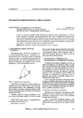
Mathematical models of rhumb line and their application / Matematički modeli loksodrome i njihova primena
(Savez inženjera i tehničara Srbije, Beograd, 2011)
The paper analyses some models of rhumb line on the ellipsoid, sphere and map projection. In geodesy and cartography, rhumb line is a complex curve on the earth's surface that crosses every meridian at the same oblique ...
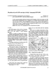
Twenty years from the first GPS measurements in Serbia: Campaign EPVGI90 / 20 godina od prvih GPS merenja u Srbiji - kampanja EPVGI90
(Savez inženjera i tehničara Srbije, Beograd, 2010)
This paper describes measurements and shows the results of the first GPS campaign taken in Serbia, realized by Military Geographical Institute from Belgrade in July 1990, within its Experimental geodetic network. As a ...
Measuring Chandler Wobble amplitude variations using IERS EOP C04 data
(Astronomska opservatorija i Matematički fakultet - Odeljenje za astronomiju, 2023)
We analyzed the Earth's long-term polar motion using the time series IERS EOP C04 (from 1984 to 2023) to determine the variation of amplitude of the Chandler wobble. To compare the results based on the C04 with the Belgrade ...