
Претраживање
Приказ резултата 351-360 од 390
The survey with the application of the modern measure instruments / Snimanje tačaka detalja primenom savremenih mernih uređaja - prednosti i nedostatci
(Republički geodetski zavod Srbije, Beograd, 2003)
The paper deals with implementation of modern technologies in cadastral surveying. Advantages and disadvantages of modern technologies are analyzed referred to classical equipment used so far. It is known that GPS can ...
Uspostava geodetske mreže primjenom globalnih navigacionih satelitskih sistema
(Univerzitet u Banjaluci, Arhitektonsko-građevinsko-geodetski fakultet, Banja Luka, 2016)
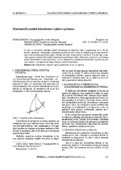
Mathematical models of rhumb line and their application / Matematički modeli loksodrome i njihova primena
(Savez inženjera i tehničara Srbije, Beograd, 2011)
The paper analyses some models of rhumb line on the ellipsoid, sphere and map projection. In geodesy and cartography, rhumb line is a complex curve on the earth's surface that crosses every meridian at the same oblique ...
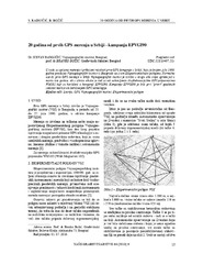
Twenty years from the first GPS measurements in Serbia: Campaign EPVGI90 / 20 godina od prvih GPS merenja u Srbiji - kampanja EPVGI90
(Savez inženjera i tehničara Srbije, Beograd, 2010)
This paper describes measurements and shows the results of the first GPS campaign taken in Serbia, realized by Military Geographical Institute from Belgrade in July 1990, within its Experimental geodetic network. As a ...
Permanent professional education of surveyors in Serbia / Permanentna profesionalna edukacija geodeta u Srbiji
(Republički geodetski zavod Srbije, Beograd, 2006)
The last decade starting from 2000 was marked by essential changes in Serbia and it is reasonable to call it as a period of transition. Though the content of surveying curricula vary between countries, some trends can be ...
Planning for sustainable development of local municipality / Planiranje održivog razvoja jedinice lokalne samouprave u Republici Srbiji
(Savez inženjera i tehničara Srbije, Beograd, 2012)
The problem of Sustainable Municipality development in Republic of Serbia is quite specific. All official agree that the development is quite slow or stopped. Forming the new association of communities and towns the process ...
Потпуни метод најмањих квадрата у функцији решавања геодетских проблема
(Универзитет у Београду, Грађевински факултет, 2016)
Doktorska teza je posvećena primeni tehnike potpune metode najmanjeg kvadrata...
A presentation method of students’ assignment in geometry-intersection of two surfaces of second order
(Serbian Society for Geometry and Graphics (SUGIG)Faculty of Civil Engineering, University of BelgradeAkademska misao, Beograd, 2016)
There are two courses concerning geometric topics in the freshman studies at the Faculty of Civil Engineering in Belgrade: Descriptive Geometry for civil engineers and Computational Geometry, for geodetic engineers. In the ...
Monitoring of erosion in the area of Đabolja Varoš: Project "Međa" / Monitoring erozije na području Đavolje Varoši: Projekat „Međa“
(Srpsko geološko društvo, Beograd, 2018)
Project "Мonitoring оf Erosion on the Đavolja Varoš site ‐ MEĐA: sustainability of natural phenomena in climate change conditions ", was created by a team of young scientists and PhD students from the Faculty of Mining and ...
Impact of precipitation and human activities on suspended sediment transport load in the Velika Morava River Basin (Serbia)
(Arabian Journal of Geosciences, 2022)
Sediment transport time series have shown a severe change in the suspended sediment load transported by the Velika Morava River (Republic of Serbia) during the last few decades. The research objectives of this study were ...