
Претраживање
Приказ резултата 381-390 од 405
Refinement of Individual Tree Detection Results Obtained from Airborne Laser Scanning Data for a Mixed Natural Forest
(MDPI, 2022)
Numerous semi- and fully-automatic algorithms have been developed for individual tree detection from airborne laser-scanning data, but different rates of falsely detected treetops also accompany their results. In this ...
Permanent professional education of surveyors in Serbia / Permanentna profesionalna edukacija geodeta u Srbiji
(Republički geodetski zavod Srbije, Beograd, 2006)
The last decade starting from 2000 was marked by essential changes in Serbia and it is reasonable to call it as a period of transition. Though the content of surveying curricula vary between countries, some trends can be ...
Teaching computing for complex problems in civil engineering and geosciences using big data and machine learning: synergizing four different computing paradigms and four different management domains
(Springer, 2023)
This article describes a teaching strategy that synergizes computing and management, aimed at the running of complex projects in industry and academia, in the areas of civil engineering, physics, geosciences, and a number ...
Impact of precipitation and human activities on suspended sediment transport load in the Velika Morava River Basin (Serbia)
(Arabian Journal of Geosciences, 2022)
Sediment transport time series have shown a severe change in the suspended sediment load transported by the Velika Morava River (Republic of Serbia) during the last few decades. The research objectives of this study were ...

Evaluation of positional accuracy of digital topographic maps at scale 1:25 000 (DTM25) on the basis of STANAG 2215 standard / Ocenka pozicionnoj točnosti na cifrovoj topografičeskoj karte masštaba 1:25 000 (TK25), razrabotannoj v sootvetstvii so standartom «STANAG 2215»
(Univerzitet odbrane u Beogradu - Institut za naučne informacije, Beograd, 2018)
The paper describes the results of the positional accuracy assessment of digital topographic maps at scale 1: 25 000 produced by the Serbian Military Geographic Institute (MGI). The test for the horizontal and vertical ...
The analysis of horizontal positional accuracy of the Digital topographic map 1:50 000 produced by Military Geographical Institute / Analiza horizontalne položajne tačnosti Digitalne topografske karte 1:50 000 izdanja Vojnogeografskog instituta
(Savez inženjera i tehničara Srbije, Beograd, 2009)
This paper describes methodology used for assessment the horizontal positional accuracy of Digital topographic map in scale 1: 50 000 produced by Military Geographical Institute, and gives review of obtained results. Two ...
The Danube reference geodetic network / Referentna geodetska osnova Dunava
(Savez inženjera i tehničara Srbije, Beograd, 2007)
The Danube is most important river in Europe today. It relates The Western European countries with The Eastern. The safety of the flyway is a primary aim of the Serbian company PLOVPUT which is in charge to make it to be ...
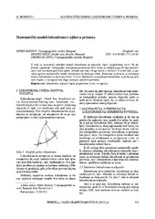
Mathematical models of rhumb line and their application / Matematički modeli loksodrome i njihova primena
(Savez inženjera i tehničara Srbije, Beograd, 2011)
The paper analyses some models of rhumb line on the ellipsoid, sphere and map projection. In geodesy and cartography, rhumb line is a complex curve on the earth's surface that crosses every meridian at the same oblique ...
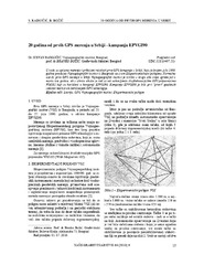
Twenty years from the first GPS measurements in Serbia: Campaign EPVGI90 / 20 godina od prvih GPS merenja u Srbiji - kampanja EPVGI90
(Savez inženjera i tehničara Srbije, Beograd, 2010)
This paper describes measurements and shows the results of the first GPS campaign taken in Serbia, realized by Military Geographical Institute from Belgrade in July 1990, within its Experimental geodetic network. As a ...
The global positioning system in geodetic surveying / Tehnologije globalnog sistema za pozicioniranje u funkciji geodetskog premera
(Savez inženjera i tehničara Srbije, Beograd, 2005)
The main task of the surveying is definition, identification, demarcation, measuring and mapping of the boundaries of the natural and artificial objects on the Earth surface. To define the relationship between points, the ...