
Pretraživanje
Prikaz rezultata 11-20 od 58

Real Estate Cadastre Development in Serbia
(Geodetski list, 2009)
This paper provides an overview development and the real estate cadastre maintenance in the Republic of Serbia. The State has recognized that an effective national property rights system is prerequisite for economic growth ...
Cadastral data services on internet in Serbia
(International Society for Photogrammetry and Remote Sensing, 2004)
Pilot project of cadastral data distribution via Internet started at the end of 2001. Reason was a pressure from users who wanted faster and improved access to cadastral data. Motive of the Governmental Geodetic Authority ...
Experiences and procedures on making technical documentation for the objects of historical and cultural heritage
(International Society for Photogrammetry and Remote Sensing, 2004)
This paper evaluates advantages of application of digital photogrammetry for the purposes of production of technical documentation for the objects under protection, comparing it with the classical photogrammetric procedures. ...
Quality analysis of digital terrain models for the test area Zlatibor / Analiza kvaliteta digitalnog modela terena na lokaciji 'Zlatibor”
(Srpsko geografsko društvo, Beograd, 2003)
Digital terrain models (DTM) have recently become products which substitute standard methods for the terrain relief presentation. As a part of a Geographic Information Systems (GIS) they represent not only a data base ...
The using GPS cinematic methods in geodetic works / Primena kinematičke metode GPS u geodetskim radovima
(Republički geodetski zavod Srbije, Beograd, 2003)
This article is explaining some standards of using GPS kinematics methods in engineering surveys. Results of GPS measurements were sufficiently accurate compared with data of terrestrial measurement.
Landslide susceptibility assessment with machine learning algorithms
(2009 International Conference On Intelligent Networking and Collaborative Systems (Incos 2009), 2009)
Case study addresses NW slopes of Fruska Gora Mountain, Serbia. Landslide activity is quite notorious in this region, especially along the Danube's right river bank, and recently intensified seismicity coupled with atmospheric ...
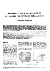
Probability maps as a measure of reliability for indivisibility analysis
(Institut za arhitekturu i urbanizam Srbije, Beograd, 2005)
Digital terrain models (DTMs) represent segments of spatial data bases related to presentation of terrain features and landforms. Square grid elevation models (DEMs) have emerged as the most widely used structure during ...
The application of the coefficients of the spheric harmonious development in the procedure of the determination functionally anomalic potential / Primena koeficijenata sferno-harmonijskog razvoja u postupku određivanja funkcionala anomalijskog potencijala
(Republički geodetski zavod Srbije, Beograd, 2002)
In the procedure of the determining functionally anomalic power, in the frame of the method remove-restore the first step presents the elimination of the long wave characteristics of the functionally with the application ...
The education of surveyors in Republic of Serbia / Sistem obrazovanja geodetskog kadra u Republici Srbiji
(Savez inženjera i tehničara Srbije, Beograd, 2009)
In Serbia, like in many other countries, there are three various levels of schools for surveyor's education: secondary, higher and academic (faculty). Except these, we must mention two academic, faculty levels - Master and ...