
Претраживање
Приказ резултата 11-20 од 23
Gerard B. M. Heuvelink, Prenos grešaka kod GIS modeliranja životne sredine, Građevinski fakultet, Beograd, 2007
(Republički geodetski zavod Srbije, Beograd, 2007)
Peter Burrough i Rachael Mcdonnnell: Principi geografskih informacionih sistema - prostorni informacioni sistemi i geostatistika
(Republički geodetski zavod Srbije, Beograd, 2006)
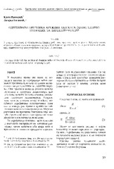
The acquisition of radius of the circle objects inaccessible for the direct measurement / Određivanje prečnika kružnih objekata (cevi) nepristupačnih za direktno merenje
(Republički geodetski zavod Srbije, Beograd, 2003)
This paper deals with the problem of obtaining radius of the circle objects which are heavy to be occupied. It is assumed that we have total station for getting the job.
The using GPS cinematic methods in geodetic works / Primena kinematičke metode GPS u geodetskim radovima
(Republički geodetski zavod Srbije, Beograd, 2003)
This article is explaining some standards of using GPS kinematics methods in engineering surveys. Results of GPS measurements were sufficiently accurate compared with data of terrestrial measurement.

Activities on improving the process of land consolidation in Serbia / Aktivnosti na unapređenju procesa komasacije u Srbiji
(Republički geodetski zavod Srbije, Beograd, 2006)
Small size of agricultural parcels, great dispersion and uneconomically shaped parcels are some of the main structural problems of Serbian agriculture. Bearing the fact that Serbia is one of the most rural jurisdictions ...

The dividing of a line at a given scale applicated to the digitalization of the points coordinates / Podela duži u datoj srazmeri primenjena na digitalizaciju koordinata tačaka
(Republički geodetski zavod Srbije, Beograd, 2003)
An application of mathematical terms for dividing a given line at a given scale is suggested in the paper. Besides this, it is theoretically shown that a conditional adjustment is present in these simple formulae.
European vertical and gravimetric reference systems / Vertikalni i gravimetrijski referentni sistemi Evrope
(Republički geodetski zavod Srbije, Beograd, 2010)
The paper provides an overview of height and gravity reference systems of Europe and a brief description of their implementation. For each system we have given definitions of the system, as well as changes in definitions ...

The TEMPUS project implementation on Faculty of civil engineering at the University of Belgrade, Department of geodesy and geoinformatics / Početak implementacije TEMPUS projekta na Građevinskom fakultetu u Beogradu - Odsek za geodeziju i geoinformatiku
(Republički geodetski zavod Srbije, Beograd, 2007)
The paper shows the contents of the TEMPUS project which was established in order to propose new master program in Land administration at the Department of geodesy and geoinformatics on the Faculty of civil engineering.
Products and application of laser altimetry surveying / Proizvodi i primena lasersko altimetrijskog snimanja
(Republički geodetski zavod Srbije, Beograd, 2007)
High density airborne LiDAR apropos FLI-MAP system, being an innovation in remote sensing techniques, has now overcome the barriers of the traditional survey techniques. Especially for long corridors like roads, railway ...

Laser altimetry surveying / Lasersko altimetrijsko snimanje
(Republički geodetski zavod Srbije, Beograd, 2006)
The airborne laser mapping, called LIDAR (LIght Detection And Ranging), provides fast acquisition of a great volume of information on the variation of the surface region through a high density of three-dimensional points, ...