
Претраживање
Приказ резултата 51-55 од 55

Značaj geodetskog inženjerstva u inženjersko-tehničkim oblastima
(Savez inzenjera i tehnicara Srbije, 2020)
Rad se bavi zakonskim utemeljenjem uloge geodetske delatnosti u oblasti građevinskog inženjerstva u Republici Srbiji. Ukazuje se na permanentno umanjenje uloge geodetske struke u praksi što može dovesti do ozbiljnih posledica ...
The Development of Land Readjustment Models in Serbia and South-East Europe
(MDPI, 2022)
Land readjustment (LR) is increasingly applied as a tool of urban policy implementation in many countries of the world. In Serbia, LR is a new tool that is being introduced into the legal system and into planning practice, ...
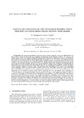
Measuring Chandler Wobble amplitude variations using IERS EOP C04 data
(Astronomska opservatorija i Matematički fakultet - Odeljenje za astronomiju, 2023)
We analyzed the Earth's long-term polar motion using the time series IERS EOP C04 (from 1984 to 2023) to determine the variation of amplitude of the Chandler wobble. To compare the results based on the C04 with the Belgrade ...

A spatiotemporal ensemble machine learning framework for generating land use/land cover time-series maps for Europe (2000–2019) based on LUCAS, CORINE and GLAD Landsat
(PeerJ, 2022)
A spatiotemporal machine learning framework for automated prediction and analysis of long-term Land Use/Land Cover dynamics is presented. The framework includes: (1) harmonization and preprocessing of spatial and spatiotemporal ...
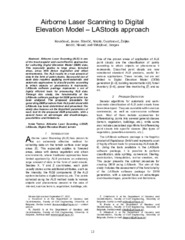
Airborne Laser Scanning to Digital Elevation Model – LAStools approach
(IPSI, Dalmatinska 55, 11000 Belgrade, Serbia, 2023)
Airborne Laser Scanning (ALS) is one of the most popular and cost-effective approaches for collecting Digital Elevation Model (DEM) data. This especially applies to large areas, forested areas, areas with dense vegetation ...