
Претраживање
Приказ резултата 1-10 од 35
The land consolidation in the countries CEE/CIS / Komasacija zemljišta u zemljama centralne i istočne Evrope i zajednice nezavisnih država
(Republički geodetski zavod Srbije, Beograd, 2002)
Each country in transition must find out its own solution for land fragmentation, thus taking already acquired experience and main common principles of the countries in Central and Eastern Europe (CEE) and of the Commonwealth ...
Development of the geodetic services market and the private geodetic practice in the Republic of Serbia / Razvoj tržišta geodetskih poslova i privatne geodetske prakse u Republici Srbiji
(Republički geodetski zavod Srbije, Beograd, 2009)
The paper contains the analysis of the market conditions for the development of the private geodetic practice in the Republic of Serbia following the latest legislative amendments adopted in 2002. The analysis was done ...

Fuzzy view of environment / Fuzzy pogled na životno okruženje
(Srpska akademija nauka i umetnosti SANU - Geografski institut 'Jovan Cvijić', Beograd, 2007)
A period of fifty years has been reached since the introduction of the first applications based upon geographical information systems (GIS). GIS has not only influenced the development of methods, collection techniques, ...
Elements of spatial data quality as information technology support for sustainable development planning
(Institut za arhitekturu i urbanizam Srbije, Beograd, 2004)
We are witnessing nowadays that the last decade of the past century, as well as the first years of the present one, have brought technology expansion with respect to spatial data gathering and processing which makes a ...
The influence of the density of the mass of the Earth's crust by the computation of the orthometric heights / Uticaj gustine masa zemljine kore pri računanju ortometrijskih visina
(Republički geodetski zavod Srbije, Beograd, 2002)
In the paper is given the analysis of the difference of the power and the geometrical relation leveling superficial and the vertikal. The influence of the force Earth's gravitation was presented on the results of the ...
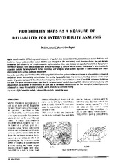
Probability maps as a measure of reliability for indivisibility analysis
(Institut za arhitekturu i urbanizam Srbije, Beograd, 2005)
Digital terrain models (DTMs) represent segments of spatial data bases related to presentation of terrain features and landforms. Square grid elevation models (DEMs) have emerged as the most widely used structure during ...

The method of the calculation of the terrain slope in the raster GIS and DTM application / Određivanje nagiba terena u rasterskim GIS i DMT aplikacijama
(Republički geodetski zavod Srbije, Beograd, 2003)
Various methods for the calculation of the terrain slope used in the gridded DTMs are presented in this work. Some of the results obtained from research based on the efficiency of the application of these methods are also ...

Current activities regarding matching the national reference frame to ETRS of Republic of Serbia and the surrounding countries / Dosadašnje aktivnosti uklapanja postojećih državnih koordinatnih sistema u ETRS Republike Srbije i zemalja u okruženju
(Republički geodetski zavod Srbije, Beograd, 2009)
In the world, as well as us, all the greater use of GPS technology, there is a justified need for the determination of transformation models between existing and new reference system. The paper presents a GPS reference ...
The application of the coefficients of the spheric harmonious development in the procedure of the determination functionally anomalic potential / Primena koeficijenata sferno-harmonijskog razvoja u postupku određivanja funkcionala anomalijskog potencijala
(Republički geodetski zavod Srbije, Beograd, 2002)
In the procedure of the determining functionally anomalic power, in the frame of the method remove-restore the first step presents the elimination of the long wave characteristics of the functionally with the application ...
Experience from professional visit to Germany: 'Follow-up' workshop / Iskustva sa stručne posete Nemačkoj - 'follow-up' radionica
(Republički geodetski zavod Srbije, Beograd, 2009)
The paper presents the experience acquired in the study tour, the German education sector, with special attention to the organization of student associations, operating processes cadastral services and private practice students.