
Search
Now showing items 221-230 of 268
Optimization of Land Distribution in Urban Land Consolidation
(INTERNATIONAL SCIENTIFIC CONFERENCE AND XXIV MEETING OF SERBIAN SURVEYORS ″PROFESSIONAL PRACTICE AND EDUCATION IN GEODESY AND RELATED FIELDS″ 24-26, June 2011, Kladovo - ,,Djerdap“ upon Danube, Serbia, 2011)
This paper describes the legal framework and the problems of urban planning in the Republic of Serbia. Basic
principles of urban land consolidation whose application would improve the urban land development are discussed.
The ...

Monitoring of erosion in the area of Đabolja Varoš: Project "Međa" / Monitoring erozije na području Đavolje Varoši: Projekat „Međa“
(Srpsko geološko društvo, Beograd, 2018)
Project "Мonitoring оf Erosion on the Đavolja Varoš site ‐ MEĐA: sustainability of natural phenomena in climate change conditions ", was created by a team of young scientists and PhD students from the Faculty of Mining and ...
Evaluation of positional accuracy of digital topographic maps at scale 1:25 000 (DTM25) on the basis of STANAG 2215 standard / Ocenka pozicionnoj točnosti na cifrovoj topografičeskoj karte masštaba 1:25 000 (TK25), razrabotannoj v sootvetstvii so standartom «STANAG 2215»
(Univerzitet odbrane u Beogradu - Institut za naučne informacije, Beograd, 2018)
The paper describes the results of the positional accuracy assessment of digital topographic maps at scale 1: 25 000 produced by the Serbian Military Geographic Institute (MGI). The test for the horizontal and vertical ...
The analysis of horizontal positional accuracy of the Digital topographic map 1:50 000 produced by Military Geographical Institute / Analiza horizontalne položajne tačnosti Digitalne topografske karte 1:50 000 izdanja Vojnogeografskog instituta
(Savez inženjera i tehničara Srbije, Beograd, 2009)
This paper describes methodology used for assessment the horizontal positional accuracy of Digital topographic map in scale 1: 50 000 produced by Military Geographical Institute, and gives review of obtained results. Two ...

The Danube reference geodetic network / Referentna geodetska osnova Dunava
(Savez inženjera i tehničara Srbije, Beograd, 2007)
The Danube is most important river in Europe today. It relates The Western European countries with The Eastern. The safety of the flyway is a primary aim of the Serbian company PLOVPUT which is in charge to make it to be ...
Mathematical models of rhumb line and their application / Matematički modeli loksodrome i njihova primena
(Savez inženjera i tehničara Srbije, Beograd, 2011)
The paper analyses some models of rhumb line on the ellipsoid, sphere and map projection. In geodesy and cartography, rhumb line is a complex curve on the earth's surface that crosses every meridian at the same oblique ...
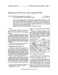
Twenty years from the first GPS measurements in Serbia: Campaign EPVGI90 / 20 godina od prvih GPS merenja u Srbiji - kampanja EPVGI90
(Savez inženjera i tehničara Srbije, Beograd, 2010)
This paper describes measurements and shows the results of the first GPS campaign taken in Serbia, realized by Military Geographical Institute from Belgrade in July 1990, within its Experimental geodetic network. As a ...
The global positioning system in geodetic surveying / Tehnologije globalnog sistema za pozicioniranje u funkciji geodetskog premera
(Savez inženjera i tehničara Srbije, Beograd, 2005)
The main task of the surveying is definition, identification, demarcation, measuring and mapping of the boundaries of the natural and artificial objects on the Earth surface. To define the relationship between points, the ...
Geodetic method using in obtaining designed geometry of civil structures / Primena geodetskih metoda u ostvarivanju kvalitetne geometrije građevinskih objekata
(Savez građevinskih inženjera Srbije, Beograd, 2009)
In this article short methodology of control measurements on engineering structures is explained. Special attention is given to the procedure of decision making related to the significance of points movement.

Comparison of IRI-2016 and NEQUICK models of the ionosphere over the Balkan Peninsula during the year 2019 / Поређење IRI-2016 и NEQUICK модела јонофере изнад Балканског полуострва током 2019. године
(University of Banja Luka, Faculty of Architecture, Civil Engineering and Geodesy, 2022)
In this paper, a comparative study of the total vertical electron content (VTEC) calculated using the IRI-2016 and NeQuick2 models were performed. The research was done for the days of maximum solar activity in 2019, with ...