
Search
Now showing items 181-190 of 214
Validation and comparison of several global geopotential models with an official quasigeoid solution of Serbia
(Association of Surveyors of Slovenia, 2022)
This study aims to analyze the quality of several local reference
quasigeoid surfaces obtained from several Global Geopotential
Models (GGM) relative to the official quasigeoid solution
of Serbia (SQM2011) and GNSS/dh ...

Agricultural Land Use Changes as a Driving Force of Soil Erosion in the Velika Morava River Basin, Serbia
(MDPI, 2023)
The erosion potential model was applied to estimate the soil erosion status of rural settlements during the years 1971 and 2011. We used univariate and bivariate local Moran’s I indices to detect and visualize the spatial ...
Positional accuracy of geographical information and recent standards for its evaluation / Položajna tačnost geografskih informacija i savremeni standardi za njeno ocenjivanje
(Srpsko geografsko društvo, Beograd, 2011)
Positional accuracy is important quantity element of quality of geographical information in digital as well as in analoguos form. This paper points to importance and necessity of evaluation of positional accuracy in recent ...
Evaluation of positional accuracy of digital topographic maps at scale 1:25 000 (DTM25) on the basis of STANAG 2215 standard / Ocenka pozicionnoj točnosti na cifrovoj topografičeskoj karte masštaba 1:25 000 (TK25), razrabotannoj v sootvetstvii so standartom «STANAG 2215»
(Univerzitet odbrane u Beogradu - Institut za naučne informacije, Beograd, 2018)
The paper describes the results of the positional accuracy assessment of digital topographic maps at scale 1: 25 000 produced by the Serbian Military Geographic Institute (MGI). The test for the horizontal and vertical ...
The survey with the application of the modern measure instruments / Snimanje tačaka detalja primenom savremenih mernih uređaja - prednosti i nedostatci
(Republički geodetski zavod Srbije, Beograd, 2003)
The paper deals with implementation of modern technologies in cadastral surveying. Advantages and disadvantages of modern technologies are analyzed referred to classical equipment used so far. It is known that GPS can ...
Mathematical models of rhumb line and their application / Matematički modeli loksodrome i njihova primena
(Savez inženjera i tehničara Srbije, Beograd, 2011)
The paper analyses some models of rhumb line on the ellipsoid, sphere and map projection. In geodesy and cartography, rhumb line is a complex curve on the earth's surface that crosses every meridian at the same oblique ...
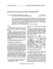
Twenty years from the first GPS measurements in Serbia: Campaign EPVGI90 / 20 godina od prvih GPS merenja u Srbiji - kampanja EPVGI90
(Savez inženjera i tehničara Srbije, Beograd, 2010)
This paper describes measurements and shows the results of the first GPS campaign taken in Serbia, realized by Military Geographical Institute from Belgrade in July 1990, within its Experimental geodetic network. As a ...
Landslide susceptibility assessment using SVM machine learning algorithm
(Engineering Geology, 2011)
This paper introduces the current machine learning approach to solving spatial modeling problems in the domain of landslide susceptibility assessment. The latter is introduced as a classification problem, having multiple ...
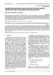
Parameter estimation and accuracy analysis of the free geodetic network adjustment using singular value decomposition
(Faculty of Mechanical Engineering in Slavonski Brod, Faculty of Electrical Engineering in Osijek, Faculty of Civil Engineering in Osijek, 2014)
In order to determine the vector of the coordinates of the free geodetic networks by the least square adjustment, it is necessary to solve a singular system of linear equations and to find the inverse of a singular matrix. ...
Refinement of Individual Tree Detection Results Obtained from Airborne Laser Scanning Data for a Mixed Natural Forest
(MDPI, 2022)
Numerous semi- and fully-automatic algorithms have been developed for individual tree detection from airborne laser-scanning data, but different rates of falsely detected treetops also accompany their results. In this ...