
Претраживање
Приказ резултата 21-30 од 207
Business plan of the geodetic enterprise in the foundation / Biznis plan geodetskog preduzeća u osnivanju
(Republički geodetski zavod Srbije, Beograd, 2003)
In this work is described the procedure of the production of the business plan. On the concrete small geodetic enterprise in the foundation has been done the projection of the indispensable financial funds to the beginning ...
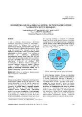
Sizing and calibration of urban stormwater infiltration system in Belgrade / Dimenzionisanje i kalibracija sistema za infiltraciju kišnice na urbanom slivu u Beogradu
(Jugoslovensko društvo za odvodnjavanje i navodnjavanje, Beograd, 2016)
This work shows a way to size and calibrate parameters of urban stormwater collection and treatment infiltration system. Its design allows collection of stormwater runoff events for a 2 year return period and infiltration ...
The influence to source of data for accuracy on Digital Terrain Models (DTM) / Uticaj izvora podataka na tačnost digitalnog modela terena
(Srpsko geografsko društvo, Beograd, 2005)
The overview of the contemporary data acquisition methods for Digital Terrain Models (DTM), as well as the accuracy of data provided by these methods, are given in this article. The procedure of the accuracy estimation for ...

The dividing of a line at a given scale applicated to the digitalization of the points coordinates / Podela duži u datoj srazmeri primenjena na digitalizaciju koordinata tačaka
(Republički geodetski zavod Srbije, Beograd, 2003)
An application of mathematical terms for dividing a given line at a given scale is suggested in the paper. Besides this, it is theoretically shown that a conditional adjustment is present in these simple formulae.
A simplified procedure of metrological testing of the terrestrial laser scanners
(Elsevier B.V., 2014)
This paper presents a simplified test procedure of the terrestrial laser scanners (TLS) accuracy investigation by the general criteria of the ISO17123 standard. The proposed procedure covers investigation, analysis and ...
Three-dimensional urban solar potential maps case study of the i-scope project
(Univerzitet u Beogradu - Institut za nuklearne nauke Vinča, Beograd, 2018)
Solar maps as web cartographic products that provide information on solar potential of surfaces on the Earth have been exploited in decision making, awareness raising, and promoting the use of solar energy. Web based solar ...
Identification of movements using different geodetic methods of deformation analysis
(Geodetski vestnik, 2015)
This paper is based on comparative analysis of applied analysis methods on geodetic networks deformation, based on two-dimensional components of GNSS baseline vectors simulated by two epochs, for the purpose of identifying ...
The education of surveyors in Republic of Serbia / Sistem obrazovanja geodetskog kadra u Republici Srbiji
(Savez inženjera i tehničara Srbije, Beograd, 2009)
In Serbia, like in many other countries, there are three various levels of schools for surveyor's education: secondary, higher and academic (faculty). Except these, we must mention two academic, faculty levels - Master and ...

Laser altimetry surveying / Lasersko altimetrijsko snimanje
(Republički geodetski zavod Srbije, Beograd, 2006)
The airborne laser mapping, called LIDAR (LIght Detection And Ranging), provides fast acquisition of a great volume of information on the variation of the surface region through a high density of three-dimensional points, ...

Laboratory for development of open source geospatial technologies: Role in education and research
(Savez geodeta Srbije, Beograd, 2014)
International Cartographic CBOs (International Cartographic Association-ICA) in partnership with the Open Source Geospatial Foundation-OSGeo has started the initiative ICA-OSGeo Labs to promote and use open source technologies ...