
Search
Now showing items 1-10 of 24

Planning for sustainable development of local municipality / Planiranje održivog razvoja jedinice lokalne samouprave u Republici Srbiji
(Savez inženjera i tehničara Srbije, Beograd, 2012)
The problem of Sustainable Municipality development in Republic of Serbia is quite specific. All official agree that the development is quite slow or stopped. Forming the new association of communities and towns the process ...
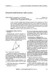
Mathematical models of rhumb line and their application / Matematički modeli loksodrome i njihova primena
(Savez inženjera i tehničara Srbije, Beograd, 2011)
The paper analyses some models of rhumb line on the ellipsoid, sphere and map projection. In geodesy and cartography, rhumb line is a complex curve on the earth's surface that crosses every meridian at the same oblique ...

Application of a software package Topocad in geodetic works / Primena softverskog paketa Topocad u geodetskim radovima
(Savez inženjera i tehničara Srbije, Beograd, 2011)
Software package Topocad is used for processing and analysis of geodetic measurements. The program is developed by Swedish company Adtollo. It contains all the options that are most frequent in the surveying jobs. This ...

Project oriented problem based learning: The first experiances of using this approach at the study program of Geodesy and geoinformatics
(Savez inzenjera i tehnicara Srbije, 2020)
Projektno orijentisan problemski zasnovan pristup učenju (eng. Project Oriented and Problem Based Learning/Problem Oriented Project Based Learning - POPBL) jeste koncept koji je prvi put uveden sedamdesetih godina prošlog ...

Doprinos određivanju jonosferskog kašnjenja GNSS satelitskih signala na teritoriji Republike Srbije
(Savez inženjera i tehničara Srbije, Beograd, 2023)
Višefrekvencijski GNSS satelitski signali i njihova dostupnost omogućavaju istraživanja u nediferenciranom i nekombinovanom modelu u kome je pojedinačni signal na svakoj frekvenciji odgovarajuće nezavisno opažanje. Ovakve ...

Designing optimal transport routes using open-source software / Izrada optimalnih transportnih ruta korišćenjem softvera otvorenog koda
(Savez inženjera i tehničara Srbije, Beograd, 2018)
Vehicle routing plays a major role in the industry, primarily in companies that organize the transport of goods to end-users. The theoretical background of the vehicle routing problem has been known for many years and it ...
Concept of implementation of consolidation in Serbia / Koncept sprovođenja komasacije u Republici Srbiji
(Savez inženjera i tehničara Srbije, Beograd, 2016)
Land consolidation means a system of spatial planning, technical, legal and socio-economic measures takes by the community for a fundamental improvement of natural, economic and environmental conditions of the land territory ...
Пројекат геодетског осматрања дела потпорног зида на аутопуту Е75 у хоризонталној равни
(Tehnika, 2019)
Деоница аутопута Е75, од Грабовнице до Левосоје, која представља јужни крак Коридора X,
подељена је на 5 деоница. За потребе реализације главног пројекта, извршен је вертикални засек терена. Паралелно са радом на засеку, ...

Designing and Realization of the Control Networks of the Telecommunication Tower Avala
(САВЕЗ ИНЖЕЊЕРА И ТЕХНИЧАРА СРБИЈЕ, Београд, 2020)
The Avala telecommunication tower was destroyed during the NATO bombing in 1999. The construction of the new tower at the same place started in 2007. The new tower consists of reinforced concrete part, with a total height ...

Determination of deflection of the vertical components by using global geopotential model EGM2008 / Određivanje komponenti odstupanja vertikale primenom globalnog geopotencijalnog modela EGM2008
(Savez inženjera i tehničara Srbije, Beograd, 2018)
This paper presents the determination of the vertical deflection components using the Global Geopotential Model EGM2008. The components are defined in two groups of points: 4083 points are relatively correctly distributed ...