
Search
Now showing items 1-10 of 45
Cadastral data services on internet in Serbia
(International Society for Photogrammetry and Remote Sensing, 2004)
Pilot project of cadastral data distribution via Internet started at the end of 2001. Reason was a pressure from users who wanted faster and improved access to cadastral data. Motive of the Governmental Geodetic Authority ...
Status of orthophoto production and applications in Serbia
(International Society for Photogrammetry and Remote Sensing, 2004)
Paper reviews achieved level of orthophoto production in Serbia, with estimates on further developments in the next few years. Users, sources of financing, application areas, state and private sector partnership, etc. are ...
Prilog istraživanju nesigurnosti digitalnih modela terena kao primarne baze podataka topografskih informacionih sistema
(2004)
U radu je razmatran uticaj nesigumosti DMT-a na rezultate analiza u kojima se ova baza
podataka о prostoru koristi. Za primer je izabrana kvantitativna geomorfološka analiza,
odnosno izračunavanje primamih topografskih ...

The method of the calculation of the terrain slope in the raster GIS and DTM application / Određivanje nagiba terena u rasterskim GIS i DMT aplikacijama
(Republički geodetski zavod Srbije, Beograd, 2003)
Various methods for the calculation of the terrain slope used in the gridded DTMs are presented in this work. Some of the results obtained from research based on the efficiency of the application of these methods are also ...

Current activities regarding matching the national reference frame to ETRS of Republic of Serbia and the surrounding countries / Dosadašnje aktivnosti uklapanja postojećih državnih koordinatnih sistema u ETRS Republike Srbije i zemalja u okruženju
(Republički geodetski zavod Srbije, Beograd, 2009)
In the world, as well as us, all the greater use of GPS technology, there is a justified need for the determination of transformation models between existing and new reference system. The paper presents a GPS reference ...
Photogrammetry of archaeological site felix romuliana at gamzigrad using aerial digital camera and non-metric digital camera
(International Society for Photogrammetry and Remote Sensing, 2008)
Some limitation brought to us by cameras and imaging platforms sometimes can not be overcome as for the case of minimum airplane flight height used as platforms. In other case imaging of larger territories is often irrational, ...
Production of country wide Dtm for serbia and montenegro
(International Society for Photogrammetry and Remote Sensing, 2004)
Project of building country wide DTM for Serbia and Montenegro is coming to its final phase. The project is based on scanning and vectorization of contours from existing 1:25000 topographic maps. Supplementing contour data ...
Application of geostatistics in spatial analyses / Primena geostatistike u prostornim analizama
(Srpsko geografsko društvo, Beograd, 2007)
During the last decade, the development of computational technique has influenced wider implementation of numerical methods in different software applications, which are oriented to processing, presentation, and analysis ...
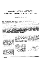
Probability maps as a measure of reliability for indivisibility analysis
(Institut za arhitekturu i urbanizam Srbije, Beograd, 2005)
Digital terrain models (DTMs) represent segments of spatial data bases related to presentation of terrain features and landforms. Square grid elevation models (DEMs) have emerged as the most widely used structure during ...