
Претраживање
Приказ резултата 231-240 од 266
The visualization of the medieval site of the Savinac monastery
(Central Institute for Conservation, BelgradeScientific Association for the Development and Promotion of New Technologies, Sopot, 2018)
Contemporary visualization techniques rely on new technological achievements which offer information data collection in the form of a three-dimensional model. Such 3D model is significant in the area of cultural heritage ...

Application of GIS based digital terrain models in the procedure of automatic classification of landforms
(University of Belgrade, Faculty of Transport and Traffic Engineering, 2020)
Sa razvojem raþunara i softvera za obradu rasterskih slika zemljine površi, danas sve više dobijaju na znaþaju postupci automatske klasifikacije zemljišnih oblika. U radu su uporeÿeni rezultati automatske i ...
Use of crash cushion systems on multilevel interchanges / Primena ublaživača udara na denivelisanim raskrsnicama
(Univerzitet u Novom Sadu, Građevinski fakultet Subotica, Subotica, 2016)
Exits on multilevel interchange ramps present potentially dangerous spots from the point of traffic safety. Therefore, a range of vehicle restraint systems was developed to reduce the consequences of traffic accidents. ...
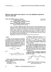
The application of the right rectangular prism in the process determining the value of terrain correction / Primena prave pravougaone prizme u postupku određivanja vrednosti terenske korekcije
(Savez inženjera i tehničara Srbije, Beograd, 2015)
The effects of topographic masses on gravity were determined for the territory of Serbia by using the digital terrain model with resolution of 1 arch second in both directions. For the effect of distant masses, i.e. masses ...

Space-time high-resolution data of the potential insolation and solar duration for Montenegro
(Institut za argitekturu i urbanizam Srbije, 2020)
The assessment of the potential use of renewable energy resources requires reliable and precise data inputs for sustainable energy planning on a regional, national and local scale. In this study, we examine ...
Примена активне геодетске референтне основе Србије у премеру непокретности
(Универзитет у Београду, Грађевински факултет, 2010)
Предмет овог рада представљају могућности и проблеми примене Активне
геодетске референтне основе Србије (АГРОС) при позиционирању тачака пасивне
геодетске основе и тачака детаља премера непокретности. АГРОС омогућује
рутинско ...
Experiment design of the terrestrial laser scanning of elongated objects
(Savez geodeta Srbije, Beograd, 2014)
In high-demanding engineering applications, the latest performance improvements of the terrestrial lasers scanning (TLS) system and price decreasing trend shows the significant potential of this technology. Beside the fact ...
Land use regimes of agricultural soils in mountainous areas of southwest Serbia
(ECOLOGICAL MOVEMENT OF NOVI SAD, 2019)
In order to raise primary agricultural production to an economically viable level, the Republic
of Serbia adopted the number of documents, strategies and laws regulating important
issues related to agriculture and rural ...
IPL Project 181 Study of slow moving landslide Umka near Belgrade, Serbia progress report for 2017 & 2018
(The International Consortium on Landslides (ICL), Kyoto, 2018)
This paper presents a brief working progress report on realization of the IPL project 181 “Study of slow moving landslide Umka near Belgrade, Serbia”. In this paper we will present results of the project targets performed ...
Mortgage market in the republic of Serbia: present situation and prospects
(Geodetski vestnik, 2013)
This paper discusses the development of mortgage loans market in the Republic of Serbia through development of the instruments for provision of legal security of investments - both to creditors and to debtors. It explains ...