
Претраживање
Приказ резултата 1-10 од 11
Methodology for selection of land consolidation areas / Metodologija za odabir komasacionih područja
(Savez inženjera i tehničara Srbije, Beograd, 2019)
Land consolidation represents the most comprehensive proven instrument of development of agriculture and rural regions. Land consolidation in Serbia has a long tradition, over 1,700,000 hectares of agricultural land has ...
Prototype of the 3D Cadastral System Based on a NoSQL Database and a JavaScript Visualization Application
(2019)
3D cadastral systems are more complex than traditional cadastral systems and they require more complex technical solutions and innovative use of developing technologies. Regarding data integrity and data consistency, 3D ...
GNSS and SAR Signal Delay in Perturbed Ionospheric D-Region During Solar X-Ray Flares
(IEEE (Institute of Electrical and Electronics Engineers), 2019)
We investigate the influence of the perturbed (by a solar X-ray flare) ionospheric D-region on the GNSS and SAR signals. We calculate a signal delay in the D-region based on the low ionospheric monitoring by very low ...
Geometric Proportional Schemas of Serbian Medieval Raška Churches Based on Stambuk's Proportional Canon
(Birkhauser Verlag AG, 2019)
In this paper, an analysis of three Serbian medieval Raška churches highlights the significance of the interaction of regular geometric shapes in the composition of their underlying proportional scheme. The complex geometry ...
The 3DNet-Catch hydrologic model: Development and evaluation
(Elsevier B.V., 2019)
Hydrologic models are important for effective water resources management. They vary in complexity from parsimonious, spatially lumped, to physically-based, fully distributed models, which are generally expected to outperform ...
Is the Second Demographic Transition a useful framework for understanding the spatial patterns of fertility change in Serbia at the beginning of the 21st century?
(AUC Geographica, 2019)
Gaps in comprehension of demographic change in the region of ex-Yugoslavia after 1990, caused by a lack of reliable data series, frequent change of borders, and distinctive historical and cultural tradition in comparison ...
The 3DNet-Catch hydrologic model: Development and evaluation
(Elsevier B.V., 2019)
Hydrologic models are important for effective water resources management. They vary in complexity from parsimonious, spatially lumped, to physically-based, fully distributed models, which are generally expected to outperform ...
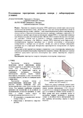
Еталонирање терестричких ласерских скенера у лабораторијским условима
(Техника, 2019)
Терестричко ласерско скенирање (ТЛС) представља методу брзог прикупљања велике количине података у виду „облака тачака“ који нам касније представља основу за приказивање реалног стања „објекта“ у виду тродимензионалног ...
Robust estimation of the normal-distribution parameters by use of structural partitioning-Perobls D method
(American journal of computational mathematics, 2019)
Spatio-temporal regression kriging model of mean daily temperature for Croatia
(Springer, 2019)
High resolution gridded mean daily temperature datasets are valuable for research and applications in agronomy, meteorology, hydrology, ecology, and many other disciplines depending on weather or climate. The gridded ...