
Претраживање
Приказ резултата 1-10 од 31

Estimation of flow accumulation uncertainty by Monte Carlo stochastic simulations / Ocena nesigurnosti prostorne koncentracije oticaja primenom Monte Karlo stohastičkih simulacija
(Univerzitet u Beogradu - Šumarski fakultet, Beograd, 2013)
Very often, outputs provided by GIS functions and analysis are assumed as exact results. However, they are influenced by certain uncertainty which may affect the decisions based on those results. It is very complex and ...
Пројекат геодетског осматрања дела потпорног зида на аутопуту Е75 у хоризонталној равни
(Tehnika, 2019)
Деоница аутопута Е75, од Грабовнице до Левосоје, која представља јужни крак Коридора X,
подељена је на 5 деоница. За потребе реализације главног пројекта, извршен је вертикални засек терена. Паралелно са радом на засеку, ...

Application of a software package Topocad in geodetic works / Primena softverskog paketa Topocad u geodetskim radovima
(Savez inženjera i tehničara Srbije, Beograd, 2011)
Software package Topocad is used for processing and analysis of geodetic measurements. The program is developed by Swedish company Adtollo. It contains all the options that are most frequent in the surveying jobs. This ...
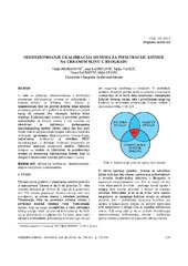
Sizing and calibration of urban stormwater infiltration system in Belgrade / Dimenzionisanje i kalibracija sistema za infiltraciju kišnice na urbanom slivu u Beogradu
(Jugoslovensko društvo za odvodnjavanje i navodnjavanje, Beograd, 2016)
This work shows a way to size and calibrate parameters of urban stormwater collection and treatment infiltration system. Its design allows collection of stormwater runoff events for a 2 year return period and infiltration ...
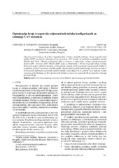
Optmizacija broja i rasporeda orijentacionih tačaka konfigurisanih za snimanje UAV metodom
(Tehnika, 2022)
Cilj ovog istraživanja je da prikaže najoptimalnije rešenje u pogledu položaja i broja orijentacionih tačaka (GCP) za potrebe snimanja terena primenom UAV metode na području prigradskog naselja Duboko kod Umke. Obrada ...

Planning for sustainable development of local municipality / Planiranje održivog razvoja jedinice lokalne samouprave u Republici Srbiji
(Savez inženjera i tehničara Srbije, Beograd, 2012)
The problem of Sustainable Municipality development in Republic of Serbia is quite specific. All official agree that the development is quite slow or stopped. Forming the new association of communities and towns the process ...
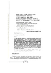
Evaluation of positional accuracy of digital topographic maps at scale 1:25 000 (DTM25) on the basis of STANAG 2215 standard / Ocenka pozicionnoj točnosti na cifrovoj topografičeskoj karte masštaba 1:25 000 (TK25), razrabotannoj v sootvetstvii so standartom «STANAG 2215»
(Univerzitet odbrane u Beogradu - Institut za naučne informacije, Beograd, 2018)
The paper describes the results of the positional accuracy assessment of digital topographic maps at scale 1: 25 000 produced by the Serbian Military Geographic Institute (MGI). The test for the horizontal and vertical ...
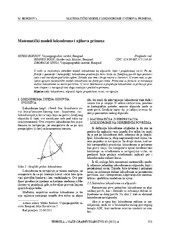
Mathematical models of rhumb line and their application / Matematički modeli loksodrome i njihova primena
(Savez inženjera i tehničara Srbije, Beograd, 2011)
The paper analyses some models of rhumb line on the ellipsoid, sphere and map projection. In geodesy and cartography, rhumb line is a complex curve on the earth's surface that crosses every meridian at the same oblique ...
Concept of implementation of consolidation in Serbia / Koncept sprovođenja komasacije u Republici Srbiji
(Savez inženjera i tehničara Srbije, Beograd, 2016)
Land consolidation means a system of spatial planning, technical, legal and socio-economic measures takes by the community for a fundamental improvement of natural, economic and environmental conditions of the land territory ...

Spatial modelling of population concentration using geographically weighted regression method
(Srpska akademija nauka i umetnosti SANU - Geografski institut 'Jovan Cvijić', Beograd, 2011)
This paper presents possibilities of applying the geographically weighted regression method in mapping population change index. During the last decade, this contemporary spatial modeling method has been increasingly used ...